Image
Credit: Dave Allen NIWA
Innovation Fund

Defining rocky reef tipping points associated with the Kaikōura earthquake

We investigated the recovery and resilience of kelp forests associated with the 2016 Kaikōura earthquake.

Project LeaderDurationBudget
Leigh Tait (NIWA)July 2017 – June 2019$300,000

Overview

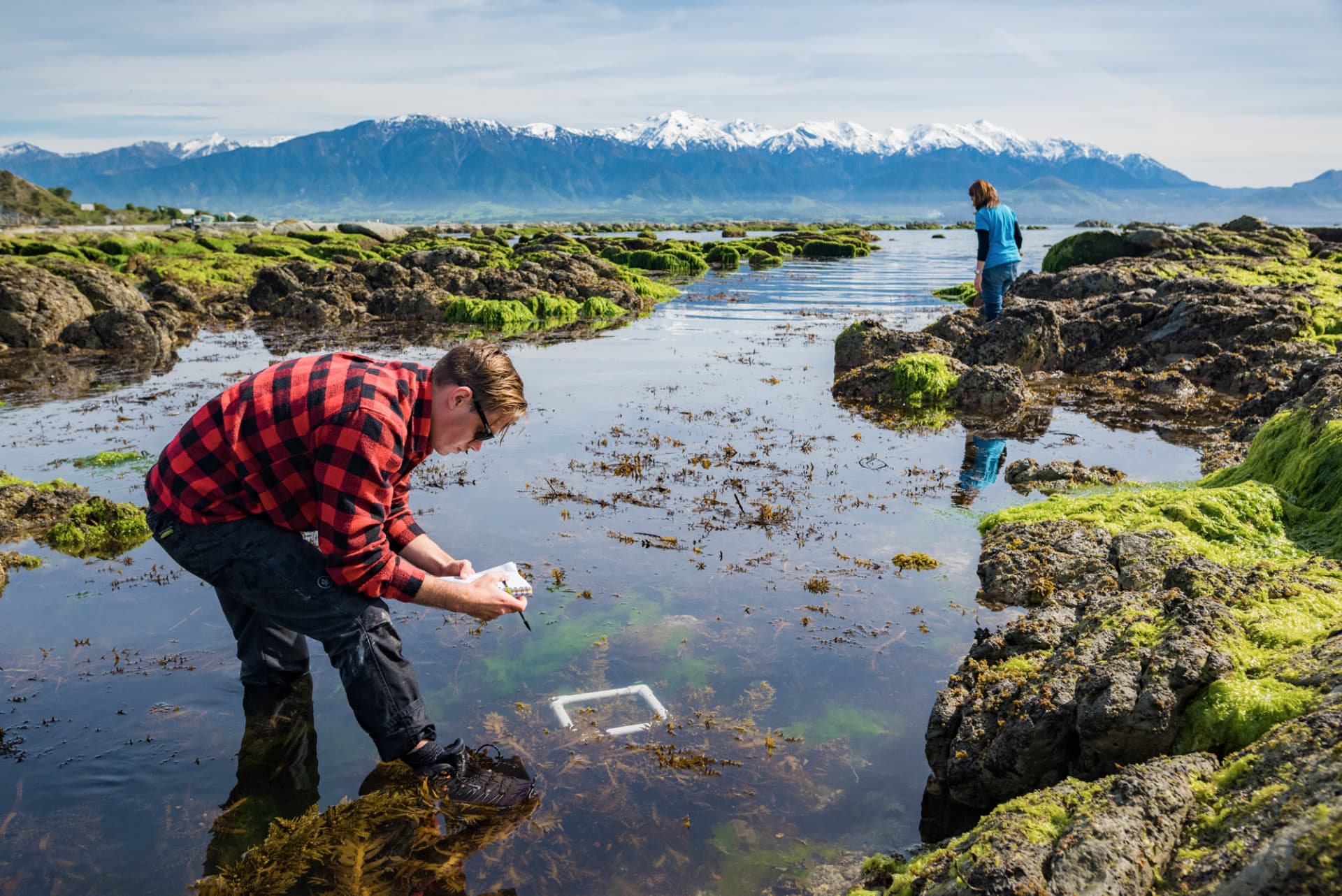
The uplift of Kaikōura’s coastline following the November 2016 earthquakes caused an unprecedented loss of kelp forests, which provide many important ecosystem services.  

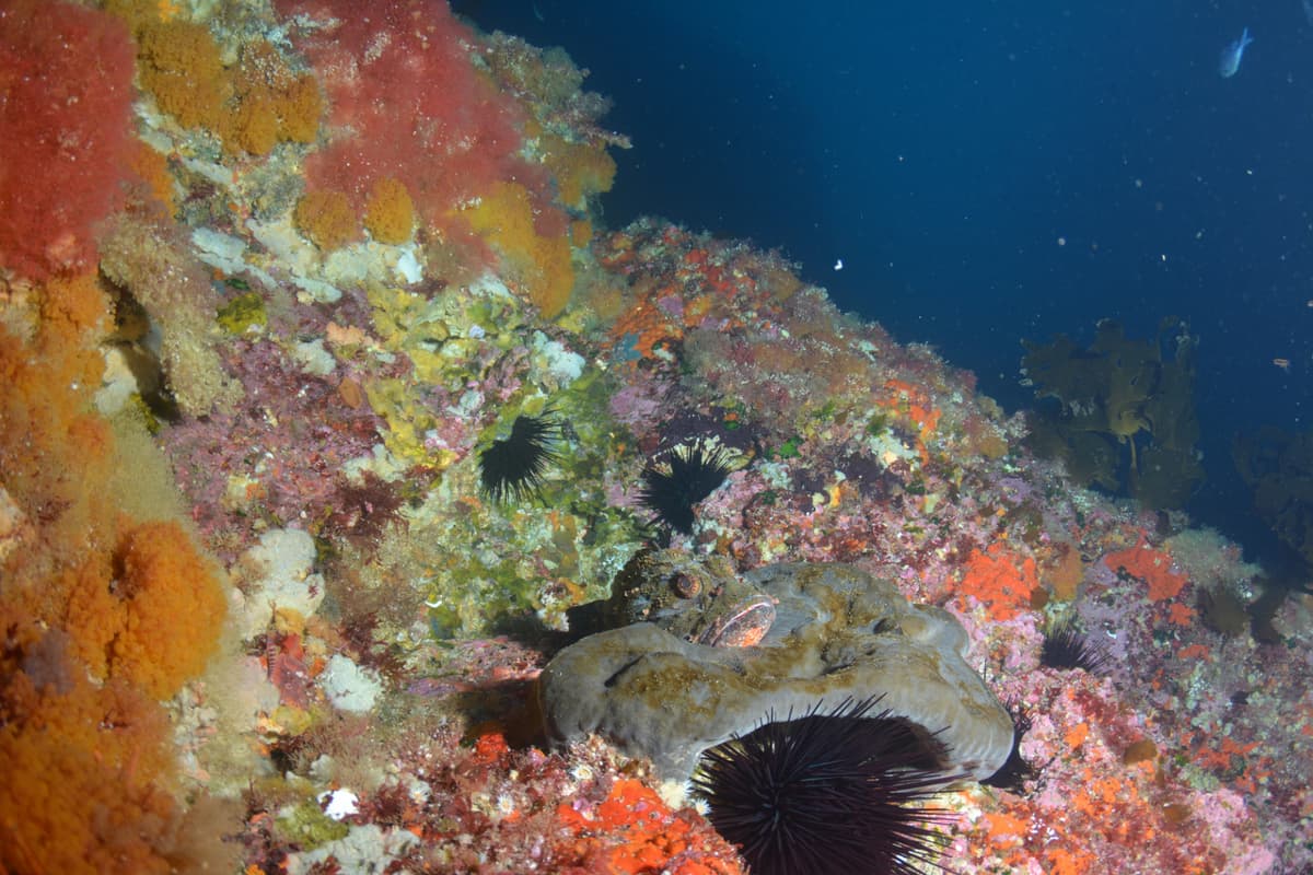
We investigated how the loss of kelp has modified the coastal environment. Kelp are a dominant species with several important roles: they fix carbon, provide habitat and food for sea creatures including taonga species like paua, buffer wave disturbance and increase dissolved oxygen. Loss of kelp has greatly reduced these ecological services along the Kaikōura coast.  

We used gradients of kelp loss to understand the alteration of ecosystem services across the Kaikōura coast. The magnitude of kelp loss across coast-wide gradients of turbidity will also inform us about the critical needs for kelp forests to survive, sustain ecosystem services and maintain biodiversity. We are assessing: 

  1. wide-scale kelp bed survival using drone images 
  2. changes in ecosystem services  
  3. small-scale recovery of kelp species.  

We have found that areas with significant kelp loss are vulnerable to suspended sediments because it reduces the light available for the plants to thrive. Pre-earthquake sediment levels had already restricted kelp to shallow waters. Post-earthquake the additional sediment associated with landslips may compromise recovery where ecological services are diminished.  

Our research provides a whole-coast assessment of potential kelp loss and identifies critical tipping points that have caused a loss of ecosystem services. This will inform sustainable management of kelp forests in the region by highlighting areas where recovery is likely, unlikely or may require intervention.  

Related News

Project proposal

992 KB | pdf

Location

This is a national project.

Tools & Resources

This project has produced or contributed to:

Earthquake impacts to Kaikōura's rocky shores
GraphicMap
This StoryMap is a visual summary of how composite images from standard RGB (red-green-blue) cameras and multispectral cameras were used to monitor kelp and seaweed biodiversity in multiple sites along Kaikōura's coast.
View
Rocky reefs after the Kaikōura quake: monitoring and recovery
Video
This short film (1m30s) summarises research on monitoring kelp and seaweed biodiversity of coastal marine ecosystems with drones.
View
Kaikōura earthquake: Summary of impacts and changes in nearshore marine communities
Academic publication
Schiel DR, Gerrity S, Alestra T, Pirker J, Marsden I, Dunmore R, Tait L, South P, Taylor D and Thomsen M (2018) Book chapter in: Shakey Shores- Coastal impacts & responses to the 2016 Kaikōura earthquakes. Henlass C, Borrero J, Neale D and Shand T (eds)
View
The Kaikōura earthquake in southern New Zealand: Loss of connectivity of marine communities and the necessity of a cross‐ecosystem perspective
Academic publication
Schiel DR, Alestra T, Gerrity S, Orchard S, Dunmore R, Pirker J, Lilley S, Tait L, Hickford M and Thomsen M (2019) Aquatic Conservation: Marine and Freshwater Ecosystems
View
Using drones to monitor marine ecosystems
Presentation
Webinar presentation by Leigh Tait, June 2019 (40 min + Q&A)
View
Unmanned Aerial Vehicles (UAVs) for Monitoring Macroalgal Biodiversity: Comparison of RGB and Multispectral Imaging Sensors for Biodiversity Assessments
Academic publication
Tait L, Bind J, Charan-Dixon H, Hawes I, Pirker J, & Schiel D. (2019). Remote Sensing, 11(19), 2332. MDPI AG.
View

Related projects & activities

Image
Tipping points in ecosystem structure, function and services
We investigated how marine ecosystems respond to change, and identified tipping points, risks and ways of managing them.
More
This project has produced or contributed to
Image
Ecosystem models
We developed simulation models for the Tasman and Golden Bays marine ecosystem to test what is likely to happen in different scenarios.
More
This project has produced or contributed to
Image
Credit: Leigh Tait NIWA
Measuring ecosystem services and assessing impacts
We developed new ways to measure and map the ecosystem services provided by marine ecosystems.
More
This project has produced or contributed to
Image
Ecosystem connectivity: tracking biochemical fluxes to inform EBM
We traced the fate of water and sediments from land through coastal food webs, evaluating connections between coastal and deep sea habitats, and identified the effects of key coastal developments (such as aquaculture) on food web connectivity.
More
This project has produced or contributed to